The geoid and GNSS
The geoid is a theoretical model of the Earth representing an equipotential surface of the terrestrial gravity field. Put more simply, it is a representation of the shape sea level would take if it could extend through continents and mountains, following the variations of the Earth’s gravity field.
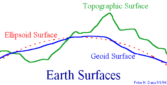
Fig.23 Representation of the geoid
Characteristics:
- Irregular and undulating: unlike a perfect sphere or ellipsoid, the geoid has an irregular shape, with rises and depressions. These irregularities are caused by variations in the Earth’s density and by the uneven distribution of its mass, which in turn affect the gravity field.
- Equipotential surface: the geoid is a theoretical surface on which the gravitational potential is constant. In practice this means that if water could follow gravity freely, with no land or other barriers in the way, its level would settle along the geoid.
- It represents the “true” sea level: the geoid is often described as the true mean sea level across the whole planet, extending beneath the continents.
- Important for height measurement: the geoid is used as the reference for determining heights above sea level. Elevations measured with respect to the geoid better represent the real “height” above mean sea level.
Note
By contrast, the ellipsoid is a simpler, regular mathematical model of the Earth, used mainly in cartography and in satellite navigation systems. While the geoid fits the actual physical shape of the Earth better, the ellipsoid offers a simplified representation that is easier to handle in calculations and mapping.
Global geoid models provide an approximation of the geoid that holds on average for the whole Earth and are used mainly for scientific purposes; they do not take local variations into account and can be used for technical work only where the accuracy required for heights is modest (of the order of a few tens of centimetres).
EGM96
EGM96 is a widely used global model in the public domain, freely available at: http://earth-info.nga.mil/GandG/wgs84/gravitymod/egm96/intpt.html
Local geoid models achieve a better approximation locally, but are valid only over areas of limited extent.
ITALGEO
ITALGEO is the local geoid model for Italy, computed by the Politecnico di Milano together with the IGM and released in successive, increasingly accurate versions.
The most recent is ITALGEO2005, consistent with the height datum of the national levelling network. Its absolute accuracy is put at about 10 cm.
It is worth noting that for technical work height differences matter more than absolute elevations, so the figure of real interest is the relative accuracy (the change in undulation between two points), which is somewhat better than the absolute one.
Note
In practice the ITALGEO geoid is used through the IGM grids for datum transformations. The .gr1 grids embed the ITALGEO99 model, while the .gr2 and .grk grids embed the more recent ITALGEO2005.
The undulation value at the points of interest is estimated by interpolating between the nodes of the grid.
Below is a model for Italy in XYZ format (ASCII Gridded XYZ), derived from the model available online. The open source GDAL library was used for the conversion to XYZ format.
ITG2009_20170606.xyz- XYZ file of the geoid undulation over Italy - Source https://www.isgeoid.polimi.it/Geoid/Europe/Italy/italgeo99_g.html
Tip
To load the file into SurPAD and work directly in the field with heights above sea level, see here.